Seeing the Invisible
- Jun 17, 2019
- 5 min read
The past is buried, and some say it should stay that way. Not archaeologists, though - they want just the opposite. But how do you know where exactly are the remains of the world long gone - so that you don't dig just everywhere and hope to get lucky?

This is the church of St. Andrew in Zgornji (Upper) Kašelj east of Ljubljana. A late Gothic church with extensive Baroque renovations was built between 1511 and 1520, just after a devastating earthquake that ravaged most of the territory of Slovenia, and crop failures and famine that followed.
The church is nothing special, save a couple of really old stones built into the façade - some Roman spolia and a gravestone inscription.

Roman gravestone in the wall of the church, by Wikipedia user Doreno.
Well, as it happens there is a Roman archaeological site in the vicinity of the church. We know that a villa rustica stood once here, and there was a small port on the banks of Ljubljanica river. A couple of chance finds - mainly pottery shards and tegulae in addition to the gravestone and other stone monuments - were discovered in the fields around the church.
Where exactly the villa is, we don't know.

Kite aerial photo of the church and the field that maybe hides a treasure ...
The field was ploughed many times over since the Romans, so nothing visible remains; even on the LIDAR the ground is perfectly flat.
But there are other ways to see what is invisible ...

LIDAR view of the area. The church is marked by a red dot. The river terrace is clearly visible; the river below changed course many times since the Romans. The purported villa rustica should be on the field above the river, to the northeast (right) of the church, and the notch in the terrace could be the site of the river port.
Aerial archaeology has made some spectacular discoveries. In times of drought various cropmarks can be seen from the air, and sometimes those correspond to buried foundations of various buildings, ritual places, circuar enclosures and the like.
The principle behind those aerial discoveries is simple: where there is a buried wall, the soil is thinner and the water evaporates faster, so the crops grow somewhat poorly there. Conversely, a bured ditch means deeper soil that retains more moisture, so the plants grow better there. The differences are visible - especially when rainfall is scarce for weeks, in the height of the summer.
However, in 'normal' weather conditions those differences in plant growth are so subtle they are invisible to the naked eye. But differences stll exist - and can be seen using different wavelenghts of light,, not visible, but ultraviolet or infrared.
Plants are good in reflecting infrared light, and healthier plants reflect more of it, so they appear brighter on an infrared photo. This phenomenon is used extesively in estimating crop heath - via NDVI, the normalized difference vegetation index - that it can be used for aerial archaeological purposes too.
We were thinking about using NIR and thermal infrared in our kite aerial endeavours, but funds are limited and, well, we've been waiting for better times. When suddenly - dr. John Wells steps in!
Dr John Wells is a retired scientist (he was a radiobiologist, even doing research of beta burns in the aftermath of the Chernobyl accident) and a master of kite aerial archaeology - especially interested in use of infrared cameras in archaeology. So as he heard our IR laments, he simply mailed us a near-infrared modified Pentax WG-10 (he really likes everybody doing kite aerial archaeology).
And what better place for a test of the camera than a field that surely hides something beneath it!

Unprocessed NIR shot of the field using a modified camera and a 720 nm filter. Wheat on the upper part of the photo seems darker than the meadow on the lower part. A road passes on the left, and strange shapes in the field next to it are areas of wind damaged stalks.
Every camera sensor is sensitive to infrared, but because IR ruins the photos, an IR block filter is installed. This Pentax WG-10 is nothing special - a perfectly ordinary point-and-click camera - it just has the IR block filter that covers the sensor removed. And voilà: an IR mod camera that shoots in infrared! With a suitable narrow filter (720 nm, above), or without (multispectral, below) it's a powerful tool for aerial archaeology.

Multispectral image of the same area. Shot without the filter, thus seen in both visible and infrared light.
NIR images don't reveal much per se. Apart from the obvious tire marks very little can be discerned, so many hours were spent processing them, trying to shake out their secrets. Contrast enhancement is one simple way to make subtle structures visible:

All 720 nm kite aerial photos stitched together and contrast enhanced. The wheat field (upper part) has different brightness than the meadow (lower part), so the they were processed separately and than put back together. Some structures are visible - but it's hard to tell if they correspond to the villa rustica.
NDVI or normalized difference vegetation index is a more poweful tool. To calculate NDVI you take a NIR and a visible spectrum photos, and then divide the sum of NIR and red channel by their difference. The result is a gradient map of differences in NIR brighntess, corresponding to health of the plants (healthier plants reflect more infrared photons):

Low resolution NDVI gradient map of the field
Not much there, huh? Well, the success of meddling with photos relies on bringing out very subtle differences, and the Roman remains that may be here would be quite small in this cca. 100 by 60 m field, so blending images into a panorama is not the way to go, as the process overwhelms them. So we did a NDVI on every pair of overlapping photos (NIR and multispectral). And maybe - maybe! - we got lucky with these two...

Pair of partially overlapping photos; 720 mm on the left, multispectral on the right
As we run NDVI on them, something pops out:

NDVI gradient map.
Well well well ... what do we have here?
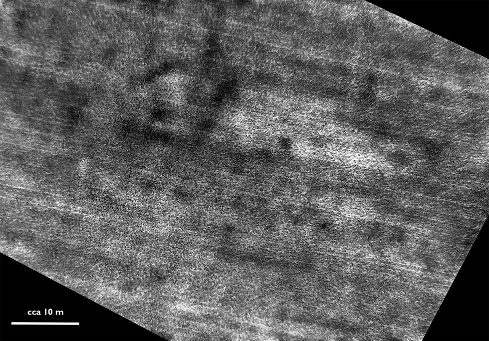
Contrast enhanced NIR
Are these shadows really long lost walls of Roman villa rustica? (BTW, "villa rustica" is a really fancy name for a simple farm.)
Again, we can't be sure until the shovels hit the ground. We've shown the photos to professionals, and while they show some interest, we wait for final verdict. Maybe we should wait with this post until then, but we just can't contain our enthusiasm :-)
***UPDATE*** we have a quick professional reply: "This is potentially it. While the direction of the structure is suspicious (being parallel to the ploughing lines), it looks like positive marks (i.e. ditches). Worth a closer look and a second visit!"

NIR NDVI of 'the structure' superimposed on the ortophoto of the area (east is up, the church of st. Andrew is in the lower left corner).
The IR photos weren't taken in ideal conditions, and we still have much to learn - both camera settings and post processing ... But anyway, villa rustica or not - aerial archaeology is much fun and very interesting. With an IR mod camera even more - and there are so many places just waiting for the kite to fly above them!

Unprocessed 720 nm shot of Viktor with his arms outstreched. Viktor is an intrepid young kiter who expertly guided the Rokkaku into the sky in very low, frustrating wind.
Thanks again to dr. John Wells who made this possible, to Viktor who lifted the venerable Rokkaku, and to everybody who is forced to bear with us going on and on and on about a Roman villa rustica in Kašelj.

St. Andrew guarding the Roman secrets ...
Kite aerial photos shot with Canon A810 (visible light) and NIR mod Pentax WG-10 (near-infrared and multispectral) - on a Rokkaku kite.

Comments