Castle Kalc, Again - and a Tribute to Slawek
- Sep 7, 2020
- 3 min read
Finally a good wind forecast made us pack the gear, and there were favourable conditions for some near infrared aerial archaeology ... So we drove again to "our" place near the medieval castle Kalc in the upper Pivka valley, to determine where exactly - and if at all - once stood an Iron age settlement and a Roman military camp, and what is all about those mysterious circles in the grass ...
...
But before we went to work we had a solemn memorial event for a kiter we met in Ahmedabad and who lost a battle with a terrible disease.
Sławek Tusky Załuski was a kite flyer from Poland, whose incessant and contagious smile brought light to the lives of so many. His line snapped way too early; now he slipped the surly bonds of Earth and dances the skies on laughter-silvered wings.
Fly in peace, Sławek.
...
The setting of castle Kalc is impressive. Though only a (recently renovated) tower still stands, the ruins are clearly visible in the lonely landscape, covered with small trees and bushes. The once magnificent tree-lined avenue leading to the main hall is still there, ancient lindens and chestnuts still guarding the entrance.

The landscape of the upper Pivka valley that was bustling since the Bronze age all the way through Roman empire and Medieval times, became unsustainable and is now mostly desolated; with only a couple of little (and beautiful) villages dotting the land.

We came here for the archaeology. We know that a Roman military outpost was built somewhere here, and the various finds of pottery shards and iron smelting remains show the place was occupied at least from the Iron age onwards, maybe even before. And this pre-Roman settlement is what we were after, with our Agrocam Geo NDVI multispectral camera.
The wind was good and with indispesable help from Maša we surveyed most of the place - over 40.000 square meters!

A karst depression now used for agriculture ... the shadow of the Royal 69 sled is visible on the right. Unprocessed NIR-G-B kite aerial photo .

Kites, kites everywhere! While one of us were doing the hard work, others flew kites for fun ... Unprocessed NIR-G-B kite aerial photo .
Aaaand ... well, we found something, just not exactly what we were looking for.
The mysterious circles stood out nicely in near infrared ...

BW NDVI image of the circles in the grass. The closely spaced dark lanes are modern (made by a mower), the thicker ones going diagonally from upper left to lower right are remains of the early medieval field partition
... but they are almost surely fairy rings, not remains of Iron Age buildings. This visible light photo confirms that there are many rings of various sizes, and therefore are unlikely to be remains of an Iron age village of roundhouses.

Fairy rings on the freshly mowed meadow
This was a bit disappointing, but we had other things to investigate ... We were intrigued by numerous barrows, and we thought that these were graves of people of the nearby settlement.

The barrows (circled in white) are clearly visible on this NDVI - normalized difference vegetation index -gradient map. Areas of lower infrared reflectance - showing poor vegetation due to underlying structures - are in cyan and blue (the larger unrelated blue rectangles are freshly harvested fields). But ...

As this decorrelation stretch image shows, the barrows are mainly at the ends of long lines. And these lines are just early Medieval field partition, remains of the times people of upper Pivka valley still did larger-scale agrculture (fields are now rare here, the low-yield soil is suitable for pastures). So the barrows are probably not graves of Iron age people. They are remains of a Medieval landscape management, when people painstakingly cleared the fieds of rocks and stones and piled them into long gravel fences, each ending in a larger barrow.
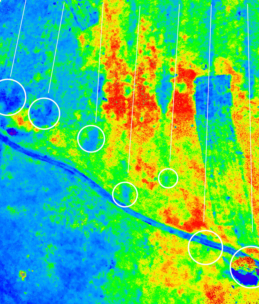
Field partition and barrows at the end of lines. NDVI gradient map.
While this is not what we were looking for, it is still a nice view of the past, a window into life that is no more.
And among the ruins and near-infrared images we can catch a glimpse of a magnificent castle towering over the land of long, fertile fields.


Kite aerial photos shot with Agrocam Geo NDVI cam on a Royal 69 sled and with Nikon P330 on a Great White delta kite.
.
Comments