Not All Roads Lead to Rome
- May 4, 2021
- 10 min read
Updated: May 6, 2021
A chance look at the right part of a LIDAR map led to a two-part KAP session, over 500 multispectral kite aerial photos, hours of image processing, NDVI calculations and contrast enhancing, poring over maps plotting directions and trying to disentangle everything - and when it finally started to make sense a real archaeologist deflated us with a laconic "probably not Roman" ... Well - probably my ass. Here is the story. It all began with this:

From a beautiful and free online map repository called Atlas okolja - the Atlas of Environment -. by Slovenian Environment Agency ARSO. You can find the LIDAR map of the whole territory of Slovenia by clicking the "Podlage" (base maps) drop-down menu on the upper left.
This is a LIDAR map of a part of Ljubljana Marshes north of the village of Ig. River Ižica meanders on the right, two roads and two large channels run through in a roughly north-south direction, and an intricate pattern of drainage canals cross this typical marsh landscape. But what caught our eye are two roughly parallel tracks going from lower left to upper right, disappearing in the boggy soil.

The western track as seen from the ground, standing on it looking southwest towards Ig. So inconspicuous it's hard to take a clear and informative photo of it. Those tracks are pretty unremarkable when you see them from the ground level - a nondescript lump, a couple of meters across and maybe 30 cm high. But it's interesting how they cross roads and drainage canals without paying much attention to them .... so the tracks were here first and are the oldest feature in the landscape. Does that mean they are ancient Roman roads?
Well, people started to make inroads into the wet heart of Ljubljana Marshes only in the late 18th century. The big road - Ižanka - that connects Ig with Ljubljana was constructed in 1848, and the drainage canals probably not long before that, so the tracks being "older" than them does not necessarily mean they are "ancient". But when our eyes see a thing like this, our brains go "Archaeology! Romans!" ...
The thing is Ljubljana Marshes are a treasure trove of archaeology. From the Mesolithic period onward people were camping and hunting here, their evolving culture culminating in famous Neolithic and Bronze Age Pile dwellings that are today a UNESCO World Heritage site. The oldest wooden wheel was found here, the Celtic Taurisci were guarding the approaches from the Mediterranean, the Romans were establishing vici and emporia and building roads between them and maybe even moved a river closer to a marble quarry ... there are so many sites and finds - and there are many many more just waiting to be unearthed.

Map of known archaeological sites of Ljubljana Marshes.
-----
One well-known Roman road - the first ever that crossed the treacherous Marshes - is still visible between Lavrica and Ig, and it pretty much looks like these tracks, just a bit wider and higher. We were there last year and we did some multispectral kite aerial photography to calibrate the camera and see if we could "see" the road using a method called Normalized Difference Vegetation Index (NDVI) mapping. It's based on a pretty cool idea that plants grow poorly if they grow over some buried remains like walls and roads, and grow stronger if they find themselves enjoying a deep ditch full of soil beneath them. One can enhance these subtle differences by taking a multispectral photograph - visible and near-infrared - and calculate the NDVI index: healthy plants reflect a bit more near-infrared light, withering ones a bit less, and by mapping the differences one can bring to light what lies hidden beneath in glorious chaos of psychedelic colours. Like this one:
A NDVI map of a part of the known Roman road near Ig - see how the plants reflect less NIR light when they grow on the road where the soil is thinner?
-----
Looking at "our" tracks we wondered why on Earth would anyone build two nearly parallel roads through an infernally difficult terrain where the Devil himself - as the stories from the Marshes tell - devours overnight everything that was built during the day? After the Romans, no road dared to cross the Marshes until 1848! Constructing one road here is half crazy - but two?


Why?
The other pressing question was where do these roads lead - as the extant structures simply and quietly disappear into the marsh. The other Roman road was leading from the vicus of Ig across the bog to Babna gorica hill where an outcrop of limestone offered the builders some respite, and on to Lavrica on the main road from Emona (Ljubljana) to Neviodunum (Drnovo) and Siscia (Sisak). But these two?
Extrapolating from their directions just before they disappear it seemed the roads aimed at Grmez hill, another solitary outcrop in the Marshes. Were the builders looking for an anchor on the hard ground - as they did building the other road - before soldiering on to the main road at the edge of the Marshes?

Were the roads going to Grmez hill (top right)?
The last question we were cocky enough to pose is where exactly did the roads cross Ižica river. Bridges are usually sturdy constructions and their foundations often stand up to the ravages of time for much longer than the roads, Plus, river crossings were important places in the Roman world; they were very inclined to throw votive offerings to the gods of rivers, for good luck and safe travel and whatnot, and many of those offerings now tell us stories about the world passed long ago. Wouldn't it be nice to have more stories from that time? It was time to fly a kite and a camera!
Kite aerial video, shot just for fun with a regular action camera.
-----
With our heads full and our excitement growing, we packed the gear and went on site. A strong breeze compelled us to use the Box Delta kite, and in no time the AgroCam NDVI multispectral camera was aloft, taking photos that were to reveal all the mysteries; the roads, the bridges, the votive treasures, and all.

Did a Roman bridge once span Ižica river somewhere around here? Uncalibrated and unprocessed kite aerial photo, AgroCam NDVI on a Royal 69 sled kite. See us holding the kite line on the right!
Almost immediately after coming back and unloading some 200 photos onto the computer, our first assumption was shattered. The thing is the Marshes are a vibrant place, literally so - everything is subsiding and growing and faulting and uplifting, and a river crossing them is no exception. While Ižica is a Karst river, springing in its almost full form from underneath a rock in the center of Ig and therefore carries very little abrasive sediment that could erode its banks, it still meanders and floods and is prone to changing course. So when - and if - the Romans were building their roads around here, the river probably wasn't flowing where it flows now! Of course it wasn't.

A meander in the middle of a meadow.
Photos revealed a meandering path crossing the marsh, hiding under the straight drainage canals. This is the old, long-abandoned course of Ižica, about 1.500 m long 20-30 m wide and almost unnoticeable in the wet meadows.

Old Ižica (marked in blue) crossing the meadows, and new Ižica on the right.
-----
Now we had a massive 3GB+ folder of multispectral photos, but most of them were shot above a wrong place ... partly because the river-crossing was not where we supposed it to be, partly because who would walk for hours around a soggy marsh with a crazy kite trying to crush your fingers and tear your hand off, and partly because of the wind's strength (way too much and growing) and direction (less-and-less-than-ideal). We needed another KAP session.
A couple of days later we were back; the wind was quite nice (if gusty) and we even had time to fly other kites before we went to work ;-)

A kite in action caught on a multispectral photo by another kite.
This time it all went well. We got the part where the roads disappear, we got the old river course where the bridges should be, we got hundreds of photos. and even enjoyed a couple of beers, Then it was processing time!

One of the tracks ("Road A"; vertical line on the right) disappears into the marsh.
One thing with kite aerial photos is that no matter how well the Picavet rig is constructed and attached to the kite line, the camera sways in the wind. The other is that the kite is stable alright, but the wind strength varies and so does the flight level. Different perspective and camera distances conspire to make stitching the photos together a true nightmare. After much coaxing we managed to persuade Photoshop to produce this - the main stitched image, showing most of the 'area of interest':

The area of interest. The old meandering river course is clearly visible, the point where Road A disappears is circled in red.
So, where are the roads hiding? We found a great online tool for processing infrared photos called Infragram, but when we put the image through their NDVI processor, we got this:

NDVI map produced by Infragram.
See anything? No? Well, pareidolia does help sometimes, and there was a hint of a ghost of a straight line. Actually of two of them:

Roads or pareidolic figments of too eager an imagination?
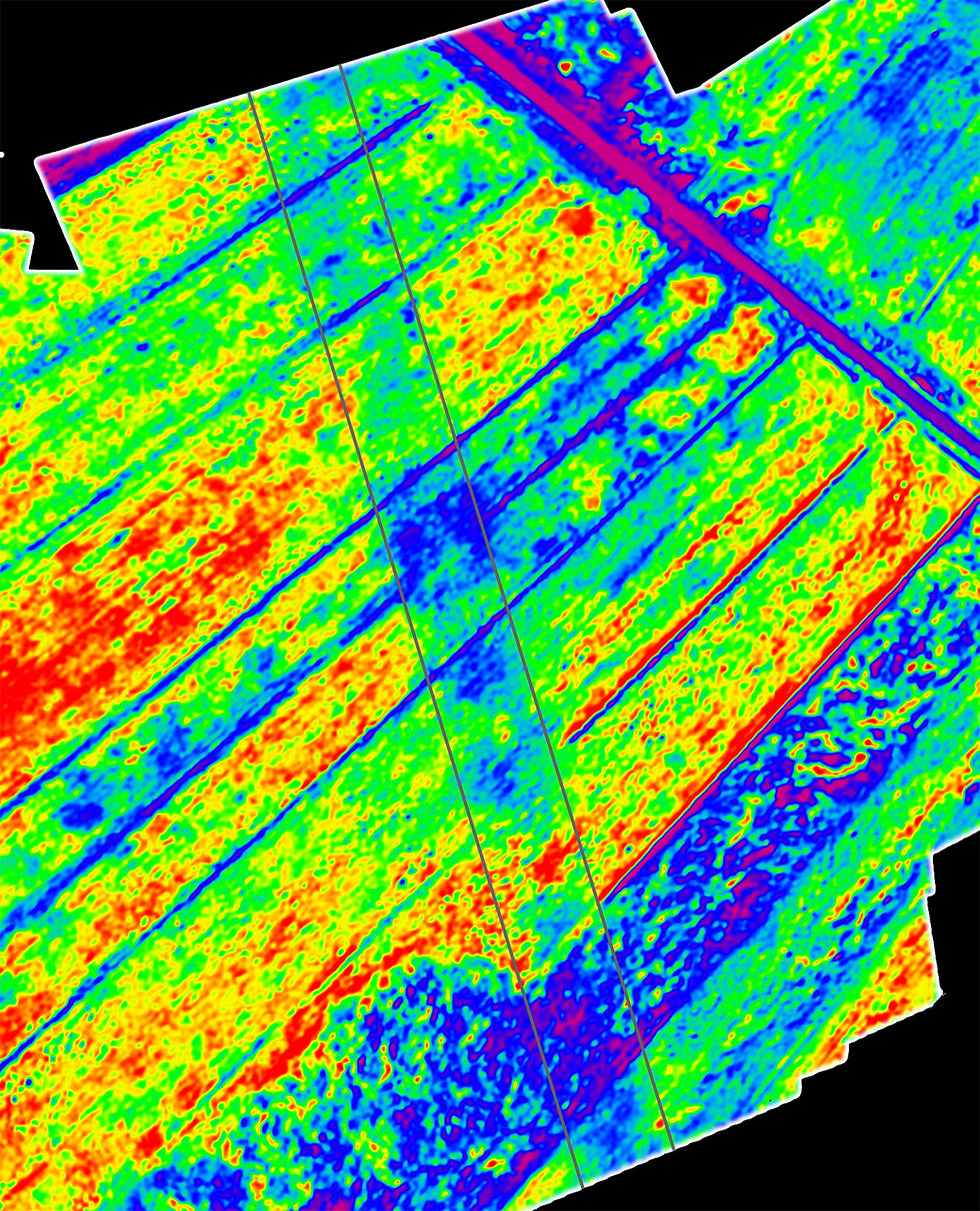
We needed to be more aggressive whilst processing the image, so we did the ENDVI map by ourselves, stretching the contrast to the limit and beyond ... and something more real started to emerge:
Now do you see them?

Enhanced contrast ENDVI map. 1 - old Ižica river; 2 - Road A; 3 - end of the visible part of Road A; 4 - Road B; 5 - river crossing of Road B; 6 - river crossing of Road A.
Two almost parallel roads - Road A and Road B - coming together and diverging just before they cross the old Ižica!
-----
The question of where did they cross the river was solved, and their directions too - they didn't deviate much from the direction of their visible parts; they almost merged, coming not more than 50 m apart, and then bid farewell and went their ways to the north and northwest. But who built them and why both of them?
We plotted the roads on the map and checked if they lead anywhere in particular. While Road A doesn't have any particular landmark in its path, the direction of Road B revealed something interesting:

Road B has exactly the same direction as an old raised road named Sinkov štradon! On a difficult terrain like a marsh it is very typical for road builders to use older roads as foundations. Even today you can drive on a part of the other Roman road we mentioned before. Do we have the same situation here - did the engineers in the late 19th century simply use a part of the existing (Roman?) road and build theirs over it? It seemed we found a major clue - and another question: why was Road B preserved but not Road A?
-----
Then we took a detailed look at the river crossings


Left: Road A crosses the old Ižica. Right: Road B doing the same, just more graceful.
Something's fishy here. Road A goes across Ižica at an angle, while Road B does it as every good road, perpendicularly. Not many engineers - and especially not Roman engineers - would build a bridge at an angle across a river; bridges are hard and expensive. Another thing is the very dark patch on the bank where the foundations of the bridge of Road B would be - remember, the darker it is the harder it is for plants to grow there, like on a well-built bridge foundation.
Then we remembered that rivers do change course - the old Ižica being a prime example - so what if ...
-----
And here is a tale from the Roman times ...:
Once upon a time, in the late 1st - early 2nd century AD, the Romans of the vicus at Ig decided to build another road across the marshes. The existing road (Ig - Babna gorica - Lavrica) was a big detour, and they wanted to shorten the travel time to Colonia Iulia Emona and its market.
They constructed Road A leading from Ig to what is today Rudnik suburb of Ljubljana, where a relay station was on the Emona-Neviodunum-Siscia road.
A decade or so later disaster struck - after particularly heavy rains Ižica overflowed and destroyed the bridge and part of Road A. High waters from the spring at Iška Loka and the river Iška were threatening the southern part of the road, so after the waters calmed, the Roman engineers chose another route.
This time they started at Debeli hrib to shorten the distance to be covered across the marshes (roads are expensive) and went south-southwest where today's Sinkov štradon road is. They built another, sturdier bridge across Ižica, kept the line straight and east of the former road to evade waters from Iška Loka, and entered the vicus of Ig from the east.
-----
Cool story, right? Everything fits together really nicely, so it must be correct. We prepared a nice paper with all the photos and maps and hypotheses and sent it to real archaeologists, expecting soon a medal and a symposium in our honour.

An intrepid aerial archaeologist walking the kite with a multispectral camera attached
...
"Well, it doesn't seem Roman to me."
"I'd say it's modern, not even medieval."
"We checked the cross-section of one of them near Ig - it's just rubble."
"A nice report you wrote, though."
Rule no.1: check with real archaeologists before you start berserking about Roman treasures.
Rule no. 2: why abandon a beautiful story just because of some facts?
A cross section of 'Road A' reveals it's just a humble, narrow, circa 30 cm thick gravel road. No wooden foundations typical for a Roman road (like the real Roman road leading from Ig to Lavrica has). They even found a couple of medieval horseshoes on it ...

Cross section of Road A near Ig. Courtesy of Dr. Dimitrij Mlekuž Vrhovnik, Institute for the Protection of Cultural Heritage of Slovenia.
It may seem it was all a big disappointment - but no, it was great. We had such fun ... flying kites, doing KAP, processing images, researching, reading interesting papers, poring over maps, talking to real archaeologists ... And we have a cool story to tell. It just doesn't get better! And eventually we will discover something: there are so many unknown and hidden treasures just waiting for a kite to fly over them.

All kite aerial photos shot with AgroCam NDVI on a Box Delta kite (session 1) and Royal 69 Sled kite (session 2). With special thanks to Ivor and Mila!
Comments